

What if the definition of a river was less about boundaries and more about the feeling you get from it? Urban designer and author Hannah Palmer talked to a photographer, ecologist, fisherman, and lawyer to find out if Atlanta’s Flint River headwaters deserve the title.
Words by Hannah Palmer | Photos by Virginie Kippelen

September 14, 2022
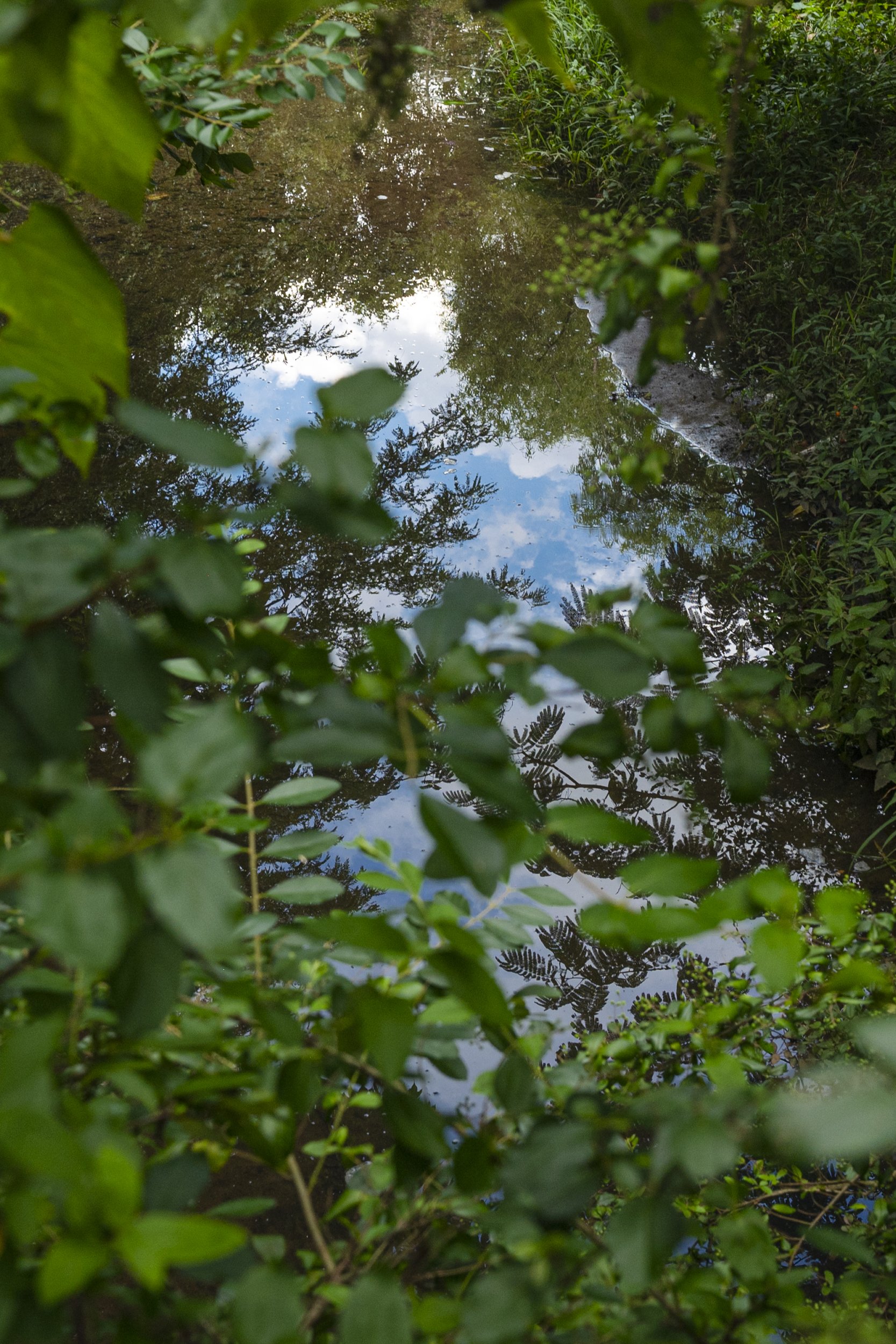
I insist on calling it a river. This concrete ditch north of Atlanta’s airport — slimy bottom, oily top, bushy edges littered with roadside blowoff — doesn’t look like much. With a running start, you could leap across it.
If you’ve visited the world’s busiest airport, as 36 million people did last year, you have almost certainly taxied over it, driven past it, browsed a duty-free shop in the terminal built on top of it. Laced beneath the 4,700-acre airport are miles of channels, house-sized box culverts, concrete pipes, and storm drains that contain the headwaters of the Flint River, Georgia’s second-longest river.
I learned a little about the Flint River while researching the communities bulldozed by the airport, but I never saw the water. You would have to be a hydrologist or a raccoon to find it. There were no signs on the bridges. The water itself being all but erased around here, I found the Flint on maps, in airport planning documents, and in the news — as a menace to be contained when tropical storms park over metro Atlanta and cause flooding, which now seems to happen every fall.

East Point water tower; 0.1 mile from the source.
First daylight in a restricted area; 0.6 mile from the source.
The Flint is both dangerous and endangered. For the last few years, I’ve worked to raise awareness about the headwaters and to help communities create and champion plans to restore the river’s headwaters with Finding the Flint. A project of American Rivers, The Conservation Fund, and the Atlanta Regional Commission, this campaign brings together water professionals, urban designers, and environmental justice advocates to dream up a better future for the Flint, and by extension, airport-area communities that depend on it. Could this parking lot be a park? Could we build a bike trail on top of the sewer line easement? Tear out some of the pavement and concertina wire separating us from our river?
In one of our first meetings with a small water and sewer department near the headwaters, an engineer referred to the Flint as the “alleged river.”
Rivers are big. Rivers are pretty. A child could tell you that. This tiny but perennial creek is neither, but according to the U.S. Geological Survey, a river begins at its “most distant headwater source.” Most rivers begin in the mountains as snowmelt, or as glaciers, or as a springhead deep in the rainforest. The Flint River begins under a water tower that says East Point, a city that was born at this convenient intersection of railroads and natural springs. From there, it flows 344 miles to the Florida state line, where it joins the Chattahoochee to create the Apalachicola River. Even when it hasn’t rained in weeks, the trickle is constant. If you squelch carefully along its banks, you’ll see tadpoles and possum, rabbit, and raccoon tracks.
I got this job because I’m a big talker, a storyteller. I talk to neighbors who are just minding their own business, trying to get to work. I tell them about the Flint River, knowing I’m a bit theatrical. Call it a river and get a reaction. Maybe that reaction will snowball into action, plans, and change.

First daylight flow at Willingham Drive in a restricted area; 0.6 mile from the source.

Virginie Kippelen lets her photos speak for themselves. A French transplant to Atlanta, Virginie has for years been studying our rapidly, often violently changing urban landscape with the fresh eyes of a documentary photographer. Her ongoing series about the Flint River’s origins reveals the devastated wildness of a place that I call home. It shows something raw and honest that I tend to gloss over in my walking tours of the headwaters. I’m optimistic; her photos are realistic.
Over the years, I have taken hundreds of residents, engineers, students, scouts, elected officials, airport employees, and other curious explorers on tours to “find the Flint.” We start at the urban source in East Point and proceed to the edges of Hartsfield-Jackson Atlanta International Airport as if on a scavenger hunt, looking for the historic stream corridor behind fences and in storm drains.
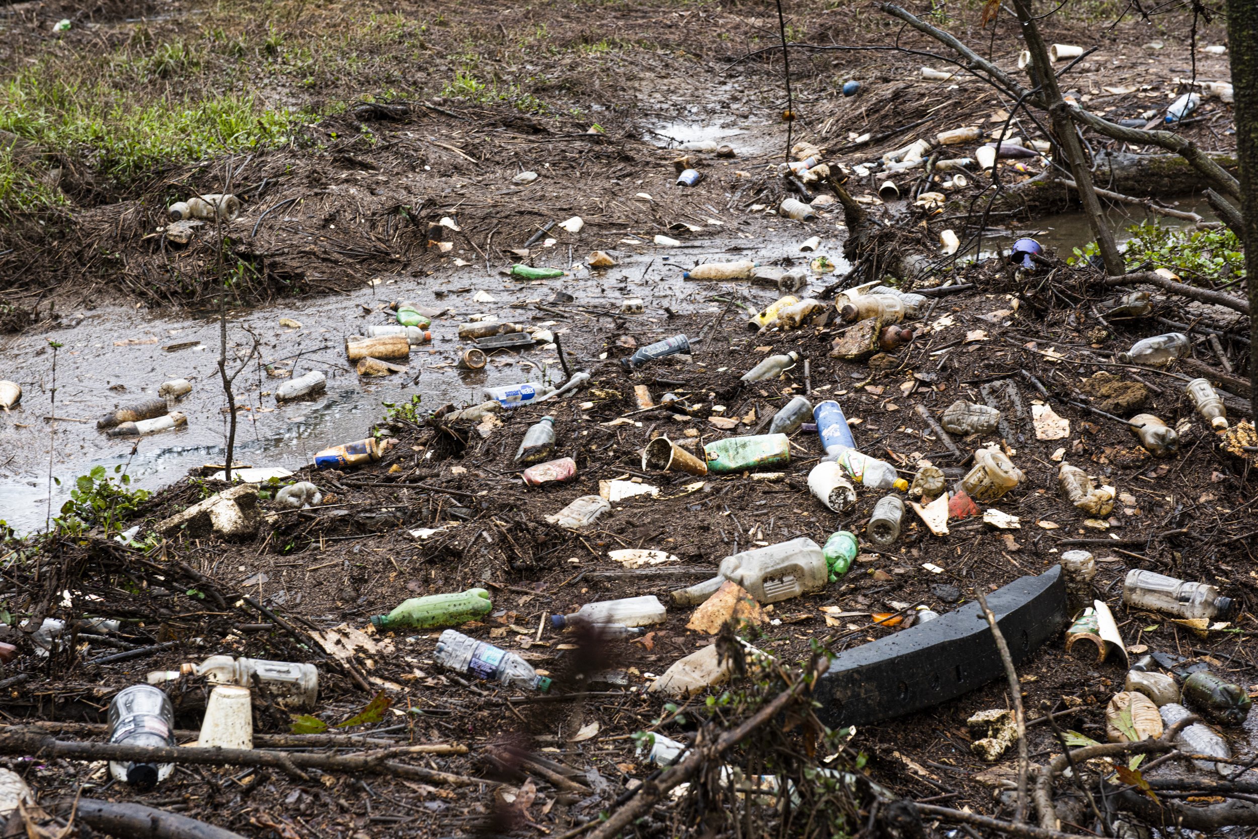
I spend a lot of time taking photos of these urban headwaters with my phone to prove they are beautiful, inviting, alive, and full of potential — all in an effort to contradict the decades-old narrative that the river is disposable, a dumping ground. Last September, an equipment failure at the airport caused a 700-plus-gallon jet fuel spill, causing fish kills in the Flint and necessitating emergency water quality monitoring for miles downstream. In 2020, I innocently led a group of state environmental leaders down to the headwaters during a major sewage spill from the airport. While all of Atlanta’s waterways suffer from some level of urban stream syndrome — erosion, contaminated runoff — these supersize airport accidents on the Flint happen with startling frequency, and involve little penalty.
Kippelen asked to shoot my portrait one October. I led her under the Forest Parkway bridge, to a spot where I have taken dozens of tours. This is where the water is finally flowing beyond airport property and starts to look like a river, or at least smell like one, with the rich roux of rotting and blooming flora everywhere. We talked about the heat, swimming, and the bleak joke of living near a river that you can’t touch.
“When we bought our house in Atlanta, I knew there was a creek nearby,” she told me. “I imagined my children playing in the creek. Little did I know.”

Next to Delta Air Lines headquarters, the fenced-off channel is the last place where you can see the headwaters before they disappear into a large culvert that runs under the airport for 1.5 miles.
The sandy banks were a riot of critter tracks and airport litter. The river’s babble was amplified by under-bridge acoustics, rippling around boulders as it meandered south.
Kippelen waited for an airplane to approach the fifth runway and cross her field of vision. “I am an avid swimmer,” she told me. “In Paris, there were these beautiful public pools. I used to swim on my lunch break, from 11:30 to 2.”
“That’s so French,” I chuckled. “Attractive public space. The long lunch break.”
“Yes. Well, I was in college.”

A glass at a Delta lounge; 3.8 miles from the source.

Nature holds sway in the airport’s restricted area; 5.8 miles from the source.
Kippelen was calm, direct, and focused. Somehow fashionable under a bridge in the muggy heat. Her photos are like her personality. None of my sugar coating or overexplaining. No concern with being likable.
Over the years, my tour groups have harvested blackberries here, spotted fish spawning beds, bobcat tracks, coyote scat, and piles of beaver-chewed sticks. Once I found a soggy $100 bill. On another occasion, I met the airport’s wildlife ecologist roaming the security perimeter. Another time, I found an emergency environmental response team pumping spilled jet fuel out of the river and into a fuel truck. I texted the Flint Riverkeeper, based downstream in Albany, then Kippelen.
I paused for my portrait, balancing on a rock by a sewer pipe, trying to smile without letting my skin touch the water.

Flint River Village shopping center on Tara Boulevard in Jonesboro, Georgia.
Sometimes I dream about the river; sometimes it gives me nightmares.
This complex appreciation is what I love about Kippelen’s work. Her photos grapple with the sometimes sinister, sometimes transcendent beauty of the headwaters, ultimately challenging our notion of natural beauty and the way we value urban wildness.
They challenge me even now. Restoring the name of the river feels like part of repairing the damage done by the airport’s growth to my community, from contaminated creeks to bulldozed neighborhoods. Am I delusional? Telling myself a story? Looking at her gritty images, I wonder. So I called a few experts who spend a lot of time thinking about rivers — an ecologist, a fisherman, and an attorney — and asked them: What is a river? How is it different from a creek or a drainage?

The headwaters flow alongside Willingham Drive from the railroad tracks, threading through backyards and behind parking lots, businesses, and hotels.

On my first paddling trip on the Flint, in 2017, we gathered at Sprewell Bluff, a county park way off the beaten path, about 90 minutes or 80 river miles south of the airport. It was a hazy, humid Monday morning in July, and a big group that included boisterous teenage summer campers, scientists, professors, and various nonprofit river folks milled around the boat ramp in PFDs and river sandals. The Flint River, wide and wild, cut its course through the Pine Mountain Range, carving out the towering bluffs, an unexpectedly dramatic backdrop for middle Georgia.
I paired up with Mary Freeman, a woman with silver braids and excellent waders. She took the stern, and I pretended to know how to paddle. It occurred to me that I had never been in a canoe before. The brown river carried us; conversation was easy. She pointed out the laurel blossoms and Spanish moss along the banks, the peculiar harmony of mountain and coastal ecosystems there at the Fall Line.
At one point, Freeman steered us over to the shallow shoals to seine for fish, and everyone followed, wedging their boats against the furry rocks. The teenagers tumbled in the rapids, distracted and flirting. Freeman trapped a few tiny darters in a plexiglass contraption and held it up to the sunlight like a pane of stained glass. The adults stood knee deep in riverweed and soaked up her impromptu lecture over the motorboat noise of cicadas, marveling at whatever career choices and good luck added up to this kind of Monday.
That’s when I learned I was sharing a canoe with a U.S. Geological Survey research ecologist, whose work in the Southeast is so influential there’s a fish species named after her and her husband — Percina freemanorum, or the Etowah bridled darter.
I gathered a whole new appreciation for river ecology from our time on the Flint. Freeman talked about the “free energy” of the river’s flow in terms of an economy — every living creature is semi-consciously looking to borrow and save energy in every movement and moment of the day. It seemed obvious to me all of a sudden, like a basic science concept that I’d missed in college while I was reading William Faulkner and Flannery O’Connor. Omnipresent and all-powerful, gravity is the river god.

Greg Brashear, a field herpetologist, catches a spiny softshell turtle in the sands of the Flint River.
As I was pondering the definition of a river, I remembered a conversation Freeman and I had as we drifted in the canoe five years ago. I was peeling an egg or a tangerine, tucking the peelings back into my lunch sack, when Freeman pointed her paddle into the timberlands and asked how far the river went. In my memory, it was a rhetorical question. As in, the river network touches everything.
I called her in Athens, Georgia, where she spends her days in the Middle Oconee River with University of Georgia graduate students studying the resilience of aquatic ecosystems, to ask what she’d meant.
“I remember you and that paddle,” she said, “but I don’t remember that conversation.”
She told me it likely wasn’t a philosophical question; she probably had a scientific publication in mind. Something about how far away from the edge of the water one can measure a river’s influence.
“There’s been a lot of papers about the aquatic insects that fly away from the river, the importance of that emergence to terrestrial animals. Birds, toads, spiders, bats — they feed on those insects every bit as much as fishes. How far can we measure that signal of aquatic subsidy going out into the landscape, into terra firma? Pretty far.”
I smiled at the poetry of “aquatic subsidy.” River economics again. She spoke of a moth in the city, thumping on your kitchen window at night, as a “signal” of the river.
“Even on [UGA’s] campus, if there’s an adult stonefly, it came out of the river. It would take me 20 minutes to walk over to the water.”

Jet fuel spill remediation near Hartsfield-Jackson Atlanta International Airport’s fifth runway on Oct. 3, 2021; 5.9 miles from the source.

Water consultant Kevin Middlebrooks points to an aquatic invertebrate living under a rock found in Mud Creek, a tributary of the Flint River; 6.3 miles from the source.
She told me that her recent studies have grown out of the droughts of 2007-2008 that shrank the Flint, Oconee, Etowah, and Chattahoochee rivers to a trickle. She’s spent the last decade measuring the flowering riverweed that grows on the shoals, and counting the caddisflies that colonize the plant and the turquoise darters that love the fast-flowing water, to understand what’s happening as Southeastern rivers become lower and slower.
When I asked her if the crummy headwaters of the Flint could be called a river, she read to me from her 2007 article in the Journal of the American Water Resources Association:
The hydrologic connectivity of small headwater streams to navigable waters is clear and unambiguous to ecologists. Every important aspect of the river ecosystem, the river geomorphic system, and the river chemical system begins in headwater streams.
A fairly radical statement coming from a USGS scientist; I had to hear that a few times for it to sink in. Freeman and her colleagues were arguing that a river’s headwaters — my slimy ditch included — are not only a fundamental part of the interconnected river system, but essential to the river’s biodiversity and health on a larger scale. The waters here were not worthless just because they were small enough to contain in a culvert.
“Everybody can observe, when it rains, the river expands. It’s the river’s tendrils up into the landscape. When it’s really wet and the whole thing is flowing, you can see it. The little stormwater drain in front of my house is absolutely part of the Oconee,” Freeman said.
I remember that paddle trip with Freeman ended with a thunderstorm. As dark clouds rolled in, the breeze chilled. We pulled our aluminum watercraft to the banks of a narrow island and huddled in the tree roots. The rain delay, seining for fish, swimming breaks, snack breaks, and flipped canoes turned a six-mile float into an all-day excursion. As an osprey circled in the wind, I wondered what economic transaction the storm provided the bird, or if it could be simply appreciating the cool rain on a hot day. More art than science.
During heavy rains, the river easily overflows and submerges wooded floodplains and roadways.

Next, I called Michi Meko, an Atlanta-based visual artist who splits his time in the studio painting large-scale, many-layered abstract landscapes and standing in rivers fly-fishing, both part of his practice of “Black navigation,” his experience of exploring wilderness as a Black man. I met Meko right before the pandemic at a backyard bonfire, and we immediately started talking about Atlanta’s rivers and how to find them.
Meko grew up in Florence, Alabama, a landscape and childhood dominated by the Tennessee River.
“Just from my background, when I think about rivers, I think about my experiences with the Tennessee River. It’s half a mile wide! When I came to Georgia, I was homesick for a river. I saw the Chattahoochee — I was like, that’s really not a river.”
Having driven that soaring bridge from Florence to Muscle Shoals, Alabama, half a mile seemed conservative to me.
“A river, you had to have a boat to go across,” Meko said. “Your friends in high school would be like, meet me at the marina and we’ll go play in the river. Let’s go to Tate Slough, let’s go skiing, jumping wave runners on barge wakes.”

An open view of the Flint River near Upper Riverdale Road, where the headwaters start to look like a real river.
Meko moved to Georgia in 1999, and the Chattahoochee gradually became his river. Fishing at East Palisades, he caught stripers, shoal bass, catfish, bluegill, and trout all in this one little section in Atlanta.
“It’s beautiful,” he laughed. “But then you read the E. coli reports.”
Now Meko does most of his fly-fishing in small streams in the north Georgia mountains, carefully circumventing private property. “I don’t want to be that Black dude in the middle of nowhere, no cell service and someone not have an understanding. I just want to catch a fish.
“Going up on all these small creeks, some of them you can’t even cast in, you’re just dipping your rod in. Even a good, strong-flowing river, in 15 steps I’m on the other side. So the Hooch is my wide river.”
In 2015, the Chattahoochee River almost killed him. Meko got stuck upside down in his kayak, submerged in the current just as his anchor caught. As he fought his way to the surface, his foot was trapped in the shoals. Luckily, two friends threw him a rope. For someone who learned to swim in a 10-foot barge wake in the Tennessee River, it’s ironic that this happened in Atlanta, just downstream from a ritzy riverside restaurant. Now, he said, “the Chattahoochee scares me.”
More recently, he was harassed at gunpoint by a park ranger in the Chattahoochee River National Recreation Area. I pictured Meko smoking languidly by his shiny black Volvo (“my spaceship”), big beard and dreadlocks, probably some stylish hat and scarf combo that only made the ranger, a “bald-headed white dude,” more determined to charge him for possession.
“He comes up to me and was like, ‘You have a tag cover, I can’t read your license tag.’” As onlookers gathered, Meko tried to keep his cool, even warned the ranger not to get poked with fish hooks as he handcuffed him. “I dropped my cigarette and he wrote me a ticket for littering.”
The South’s industrial rivers like the Tennessee or the Mississippi are big enough to carry cargo ships and barges, to cool nuclear power plants. According to Meko, a small river is still enough to fish in, or kayak in, or drown in. It’s enough to carry big experiences, big threats.

A pipe along the side of Upper Riverdale Road's bridge. The bridge is periodically flooded, cutting off access to Southern Regional Medical Center from I-75.

On my call with Freeman, she told me lawyers often have to make distinctions about what constitutes the river ecosystem and the riparian zone, the land on the edges of the river.
“[Lawyers] are trying to put a boundary where there's not a hard one. There are boundaries, but they're soft boundaries and things move across them.”
So I asked an attorney to define river for me.
“Legal definitions are extremely powerful,” said April Lipscomb, a senior attorney at the Southern Environmental Law Center. I am acquainted with Lipscomb because, unfortunately, what I’ve documented on the Flint’s headwaters isn’t all butterflies and rainbows.
“They’re intended to create clarity or avoid uncertainty, but they don’t always do that.”
She explained that the state of Georgia, anticipating such syntactical nitpicking, defined “waters of the state” as protected. She emailed me the state code:
“Waters” or “waters of the state” means any and all rivers, streams, creeks, branches, lakes, reservoirs, ponds, drainage systems, springs, wells, and all other bodies of surface or subsurface water, natural or artificial, lying within or forming a part of the boundaries of the state which are not entirely confined and retained completely upon the property of a single individual, partnership, or corporation.
This is much more broad than I expected. Under this definition, our urban creeks should be receiving the same protection as a fly-fishing stream in the mountains.
“I actually really like the definition of waters of the state,” said Lipscomb. “It recognizes that waters deserve protection even if they have artificial components. And that’s important, because so many have been channelized. You put a stream in a tunnel to go under highways, subdivisions.”
“Or runways,” I interrupted.
“All water flows downstream, so they are all recognized as waters of the state. It’s illegal, for example, for someone to dump solvents into ‘waters of the state.’ Or jet fuel.”

Gordon Rogers, Executive Director of Flint Riverkeeper, points to the Flint River at Sprewell Bluff; 80 miles from the source.
That’s good news for the polluted stormwater channels beneath Hartsfield-Atlanta airport. But not exactly proof that I’m correct to call them a river.
Then Lipscomb surprised me with an offhand comment that reminded me of Meko’s change in perspective.
“I’ve been thinking about your question,” she started. “In my work there’s this legal definition — Is there flowing water? Are there banks? But I don’t feel anything when I read the legal definition. When I go see the Flint at Yellow Jacket Shoals, seeing that body of water is going to elicit some kind of emotional response. Wonder or appreciation. Or at the airport, sadness.”
This matched up well with what Meko was saying — that the Chattahoochee became a river to him over time, in context, and with experience. Yellow Jacket Shoals is down at the Fall Line, Class III rapids, shoal bass, a fierce legal battle over fishing rights.
So an expert in environmental law was telling me the meaning of a river just comes down to … vibes? If that’s the case, Kippelen’s camera is trained on a river, even as her photos push against the idea of “beauty” in nature. Her images are unsparing in showing just what we have done to the river.
When I take people out to visit the headwaters, we start at the source, on a street formerly known as New Spring Street in East Point. I stop passersby and security guards, people walking their dogs or exiting the MARTA bus. Did you know this is the Flint River? They look surprised or confused or betrayed, but never indifferent. Some seem defensive — “but this is just runoff, right?” — as if water can be divided into waste versus resource. Some smile proudly and tell me they grew up fishing on the Flint, way downstream in the country. Most everyone is startled to think that this becomes much more significant, flows to the sea. When you call it a river, it feels like a crime. It also feels like a miracle.

Hannah Palmer serves as the coordinator of Finding the Flint. A native of Atlanta’s Southside, she wrote about the neighborhoods erased by Atlanta’s growing airport in her memoir Flight Path. Exploring the privatized, segregated, and sullied waters of the urban South with her family has led to a new book project and her latest brainchild, Atlanta Creek League.
Virginie Kippelen is a photographer whose work explores the visual representations of the natural world, investigating themes that include the sense of place, the notion of wilderness, and the visualization of climate change. She engages with these questions through the practice of both documentary and conceptual fine art work. She received a 2021 fellowship from the Blue Earth Alliance for her “Lost in Sight” project. You can find more of her work at www.virginiekphotography.com.


