

A five-lane highway expansion threatened to destroy the Phillips community, a historic heirs’ property settlement community near Charleston, South Carolina. The neighborhood fought back and won — but survival is still a delicate art.
Story by Josina Guess | Photos by Gavin McIntyre
September 8, 2022
They take our land / They take our rights / But they’ll never know our power / We put up the fight.
— Ranky Tanky, “Freedom”
“You know how long it takes to do this?” Richard Habersham asks, cradling a 5-foot fishing net made decades ago by a long-departed neighbor. The endless wave of Charleston traffic hums as he spreads the nylon web on his lap. Habersham shows the subtle shift in knot pattern that allows the conical net to flatten when it hits the water. He remembers watching his neighbor sit out on his porch making cast nets with a palm-stem needle, his hands deftly looping in a blur of well-practiced precision. Habersham says it would take about two weeks to craft one net.
Habersham, 68, a retired truck driver, doesn’t count the hours he spends advocating on behalf of Phillips, the small unincorporated community in Mount Pleasant, South Carolina, where he and his family have lived for generations. “But it’s a lot,” he concedes. “It’s a lot.”
He’d spent the previous afternoon showing me around Phillips, introducing me to neighbors Jonathan Ford and the Rev. Elijah Smalls and walking me through pines, palms, and graves. We talked about his work as president of the Phillips Community Association and their hopes for the community’s survival. The historic heirs’ property settlement community was founded in the 1870s by formerly enslaved African American people. Two years ago, Charleston County proposed a five-lane highway expansion that would have imperiled the delicate threads that make Phillips what it is.

Richard Habersham walks away from a bridge over Horlbeck Creek in the Phillips community.
He pulls the nets from the back of his pickup and we sit on a bench in front of The Cigar Factory on East Bay Street, a 25-minute drive from Phillips. Temperatures are in the mid-90s. People come and go from air-conditioned buildings, but for a brief moment we are frozen in time. The cast net, like sweetgrass baskets and the Gullah way of speaking, even the simple act of sitting outside on a hot day, are among the many links connecting Habersham and his neighborhood to a centuries-old cultural heritage.
Habersham holds these strands in his fingers. His grandfather was a fisherman, his days shaped around nets and tides. His great-grandfather ran a gristmill, where his days revolved around mules and corn. Habersham doesn’t spend his days by the water or tilling soil. His is a world of maps and meetings. Flip phone in hand, Habersham dials numbers and strategizes to build an expanding network of support to preserve his community.

A few blocks down East Bay Street, in the Charleston office of the Southern Environmental Law Center (SELC), Jenny Brennan outlines the ongoing struggle Phillips and many communities like it face. “Settlement communities along the coast are being increasingly pushed out by growth pressures, development pressures, and property taxes,” Brennan says.
The proposed five-lane highway project, known as Alternative 1 of the Highway 41 widening, would have been the end of a way of life for a neighborhood that has weathered nearly 150 years with a sense of cohesion and continued connection.
“The road was going to go right up to some people’s doors,” Brennan says. Although the proposed plan suggested that no one would be displaced, houses along the direct route would have been unlivable. “You open your door and there’s a five-lane highway, it’s ridiculous,” Brennan says, envisioning the widened road as originally planned.
“It would be the death knell [for Phillips]; it would be really difficult for anybody to hold onto their land at that point.”
Back in 1942, Highway 41 cut through the largely self-contained Phillips. The two-lane road split family plots, leaving houses on one side and triangles of land, family, and friends on the other. The old Phillips school had been in the middle of the path of Highway 41. The road builders moved the school building to one side, leaving the outhouse on the other side. Already subjected to unequal spending in segregated schools, Phillips schoolchildren had to cross a two-lane road just to use the restroom. In those Jim Crow years, no one asked Phillips community residents for their input.
This pattern was repeated across the United States. A boom of highway construction in the 1950s and ’60s destroyed and often targeted Black neighborhoods, displacing at least 1 million people. In the Charleston area alone, highways 526, I-26, and 17 were built through and continue to negatively impact Black communities.
For the first half of the 20th century, Mount Pleasant was a rural fishing village of around 5,000 people. The population continues to swell and has risen to 95,300, making the city the fourth most populated in the state. All those people make for a lot of traffic.
With the increase in traffic and development, the Phillips Community Association had been anticipating a need for traffic mitigation. In 2005, with help from the Coastal Conservation League (CCL), the Phillips Community Association worked with a private consultant to design a three-lane road and roundabouts that would improve traffic flow and not displace anyone. This plan was presented to the Charleston Area Transportation Study (CHATS) and included as a viable option under consideration. By early 2020, the county had 12 options: Alternative 7a, which was built on Phillips’ 2005 plan, was favored as it avoided major impacts to the community. “All signs pointed to 7a,” said Jason Crowley, CCL’s senior program director for communities and transportation, “because it was just as fast and easy.”

Traffic drives along Highway 41 past a historical marker for the Phillips community.
In early August 2020, Charleston County presented Alternative 1, a plan to widen 41 to five lanes. Because of COVID-19, attendants would meet on Zoom. The people of Phillips, many of whom are elderly, insisted that it be in person, outdoors, with masks and careful social distancing measures in place. After announcing its selection of Alternative 1, the county asked Phillips residents to express any concerns one on one at designated tables. Instead, the people of Phillips stayed together and expressed their concerns publicly. They made it clear that Alternative 1 did not reflect the neighborhood’s input.
Brennan was at that meeting, as was Crowley from CCL. Though people were respectful at the meeting, they both remember emotions running high among residents who feared their neighborhood would be destroyed and that all their efforts to present a meaningful alternative had been ignored. Crowley and Brennan left that August meeting energized to act. Brennen went home, and got to work, beginning with “a ton of emails.”
Dozens of organizations and local historical preservation and advocacy groups joined in, recognizing the flaws in the proposed highway expansion. David Slade, who has reported extensively about Phillips, wrote about that meeting in The [Charleston] Post and Courier. Other news reports and opinion pieces spread local awareness. After an open comment period, thousands of people weighed in on behalf of a neighborhood of a few hundred people. In 2021, the Charleston County Council voted on a revised compromise that is very similar to 7a.
“What helped was [our partners],” Habersham reflects, knowing that those relationships and expanding network of people helped them win. “We started complaining in 1999 about the comprehensive plan and said we wanted a three-lane highway with some roundabouts. Went to the Coastal Conservation League, Coastal Community Foundation, and Jennie Stephens with the Center for Heirs’ Property [Preservation]. Having those connections helped a whole lot. When we had people backing us, that made a big difference.”
“This story has been told before,” Brennan says, “where there has been a road put through an heirs’ property settlement community and people didn’t bat an eye.” By connecting the intersecting loops of history, environmental justice, and cultural preservation, Phillips was able to change its story.

Inside his one-story home in Phillips, Habersham digs through piles of maps. Although he has lived in Phillips his whole life, the house he lives in was built in 1989. He jokingly calls himself the poster child for his neighborhood, but to many, Habersham is the map man. He starts with the pile beside the white couch in his living room, and then moves to the back room. After rustling through the stacks, he emerges with three maps.
He unfurls the first one to show how the shape of the neighborhood has remained largely unchanged for more than 300 years:
Plan of a body of land. Located in Christ Church Parish — Consisting of 500 acres granted to Robert Fenwick in 1694 but now belonging to Sarah Rutledge in 1768.
“We can document this history from its founding. [Phillips] was the Rutledge Plantation,” Habersham explains. Sarah and her husband, Dr. John Rutledge, had seven children, the most famous of whom were John Rutledge, a framer of the U.S. Constitution and the first governor of South Carolina, and Edward Rutledge, the youngest signer of the Declaration of Independence.
“This is their birthplace,” Habersham continues. “How many other places can document two founding fathers born in their community?”
Of course, the history of people on that piece of land goes further back than Fenwicks and Rutledges. Indigenous people who first lived here were decimated by disease and genocide. Linguistic traces remain in the names of places like the nearby Wando River. Soon, African people who survived the transatlantic slave trade were forced onto this landscape. Vast wealth was built upon their stolen labor upon stolen land.
Habersham has learned more African American history in the past 20 years of neighborhood advocacy than he ever learned in school.
“Did you ever see how they fed the [enslaved] kids?” he asks. “In a hog trough! In a hog trough!” he says, shaking his head. “Some of the other things they did, whoa, they don’t want to tell you all that stuff, or tell how cruel it was. Some people say, ‘All slave masters weren’t cruel.’ What? Owning slaves was cruel!”

Richard Habersham points to a copy of a map of the Phillips community from the 1700s.
The next map Habersham lays down shows the land in 1875. In the years following the Civil War, many farms were abandoned or sold off. Phillips’ founders paid around $10 per acre for the former pecan plantation. They included, notably, four Civil War veterans and two female heads of household, Sarah Wiseman and Betty Bailey. Most purchased 10-acre plots, but 70-year-old Sippio Smalls — the great-grandfather of Habersham’s neighbor the Rev. Elijah Smalls — purchased 35 acres, and Thomas Tonneau, who owned a boardinghouse, bought 25 acres.
Phillips’ founders set to work chopping down pecan trees to make way for wooden houses, churches, a school, a Society Hall, and acres of farmland. The community was once largely self-sustaining, growing rice, meat, fruit and vegetables.
“It’s no question that slavery was evil, that’s a given. It’s what our ancestors did just 10 years later,” Habersham says, “to save and purchase this land for their grandchildren. Imagine what they did to survive, and the culture that they brought forth. That’s what amazes me!”
Over that map, Habersham lays a current map of Phillips; many of the parcels of the 422-acre neighborhood are the same and have remained in the same families since the 1870s. As families grew, more houses popped up around original homes. He points to large yellow rectangles indicating land that used to be part of Phillips but was annexed by Mount Pleasant.

The RiverTowne development, seen from Horlbeck Creek.
His finger hovers over Phillips Creek, a nearby development with homes starting at $700,000, and points to places with names like Dunes West, Park West, and RiverTowne. These encroaching developments aren’t just raising the tax base and real estate prices, they have increased the flow of water and traffic through Phillips, too. Though Habersham describes Phillips as an island within Mount Pleasant, geographically, it is becoming more like a valley, as developments literally raise the ground around them.
“Before, we didn’t have a problem with flooding,” Habersham explains. Developments started popping up in the 1980s, and developers continue to build. “Park West is the major development around here. When they cut all the trees down, they elevated their property. Where does all that water go? Water goes to the lowest point.”
In a public response to Alternative 1, SELC described how developments add to both traffic and stormwater runoff. This results in flooding through “the associated destruction of wetlands and proliferation of impervious surfaces. …” With more roads and buildings and fewer trees and wetlands, drainage has become a major issue for coastal communities. “The [Phillips] community now experiences regular flooding that causes significant damages to property and traps residents due to flooded roadways,” the letter continues.
“I’ve been living here [in this house] 32 years,” Habersham tells me. “The last major storm we had, I had water in my garage. You couldn’t see my yard — the water went across 41.” The expansion plan would only have made it worse.

Habersham drives me to an open-air pavilion on a 10-acre undeveloped wooded parcel and points to where a baseball and football field used to be. The Community Association, with support from the Charleston County Greenbelt Program, purchased this plot of land for a little under $1 million and has plans to build a learning center and a Society Hall, much like the one the founders built, while leaving the majority of it in its natural state, including revitalized walking and biking trails.
Jonathan Ford unloads a few boxes of pizza and chicken wings along with a cooler of water and sodas before we sit down. “He’s the community chef,” Habersham says of Ford, who keeps everyone well-fed at Phillips’ community day picnic and other events. As we wait on the Rev. Elijah Smalls to join us, Ford, 63, retired from over two decades in the military, gives me a crash course on local taxes, property values, community engagement, and intergenerational prosperity.
“What was left to us was like money in the bank; it was wealth to us. You could always come back home,” Ford explains. But it's getting harder for low- or fixed-income homeowners to maintain their homes, a story that is playing out in urban and rural communities across this nation.
“Let’s say I’m a developer,” Ford explains. “And I, basically, don’t — well, I have a heart, but I tuck it back in the corner somewhere; and I know that you can’t pay the taxes on your property. I’m not gonna say, ‘Hey, let me give you $10 million on this property.’
“No, I’ll just wait until you can’t pay the taxes, either buy it on sheriff's sale or I’ll wait until you’re desperate and pay you $100,000, and then sell it for $5 million.”

The Rev. Elijah Smalls (left) and Jonathan Ford sit at a table in the Phillips community gathering area.
Sales of heirs’ properties can get especially dicey, and they rarely, if ever, profit the seller. If a property owner dies without a will or a clear way to transfer the title, the property automatically belongs to all heirs. When an heir wants to sell, an enormous amount goes to lawyers’ fees because three attorneys are needed: a lawyer for the seller, a lawyer for the buyer, and a lawyer for the unknown heirs. It can take several months or years.“Things can get crooked,” Ford says.
If a sale goes through, what’s left, after lawyers’ fees, is distributed among the heirs. A $500,000 sale divided among 10 people wouldn’t enable anyone to purchase land or a house in this region.
“It seems like a lot of money, but when you break it down, it's not that much,” Habersham adds. “What you gonna do with $50,000 in this area?”
Habersham says 10 heirs is a generous estimate, since some heirs’ properties have more than 100 claimants spread out across the country. For the ones who could have lost their homes through the highway expansion, there would have been little hope of return to local homeownership. In July 2022, the median list price of single-family homes in Mount Pleasant was $849,600. Working-class people are being increasingly priced out of the area.
“You’ve got people right on the edge of poverty and you’re throwing them in the deep end of poverty,” Habersham says. “That’s what the road would have meant.”
The Rev. Smalls, 79, a retired respiratory therapist, joins the conversation. I had said something about the importance of talking openly about things that a lot of people don’t like to talk about, like racism, classism, and climate change. Smalls, a minister at Greater Goodwill AME Church in the nearby Seven Mile community, offers a word.
“Those who are suffering the racism don’t mind talking about it,” he says. “Those who are abusing it, they don’t want to hear anything about it. Until someone is able to say, ‘Well, I’m sorry; I was wrong,’ there won’t be any headway made, and the abusers, they won’t say that.”
“We never wanted to fight the white-Black issue,” Ford emphasizes. “We’ve got deeds, our people bought this property, we are property owners, we’re taxpayers. We want the same thing that’s granted to other taxpayers. If you listen to them, listen to us.”
Although the Phillips community is satisfied that Highway 41 will not expand, residents know there are ongoing struggles to maintain and hold onto property.
“It’s the quality of life, it’s not an investment,” Ford says. “It’s home.”

Phillips’ struggle is not unique, but the victory could help more individuals and communities hold onto their homes, a fight that the Center for Heirs’ Property Preservation knows all too well. Josh Walden began as a supervising attorney in 2009 with the North Charleston-based center and is now the chief operating officer. Before that, he’d been practicing law for several years and felt like he wasn’t actually putting his law degree to good use. Now he has the satisfaction of helping provide legal services to people who wouldn’t have been able to afford it. Under the leadership of Jennie Stephens, the center has grown from working with heirs’ property owners in five South Carolina counties to serving 22 counties. They also get calls from across the country; Walden had recently fielded calls from Oklahoma, Florida, and Virginia. He helped clarify the differences between heirs’ property settlement communities and heirs’ properties.
Phillips, as a settlement community, was formed by a group of people over a century ago and has a sense of cultural and geographic cohesion. The term “heirs’ property” can apply to any single piece of real estate whose owner died without leaving a will. Heirs’ properties can be in urban, suburban, or rural communities of any ethnic background. The common denominator is that people with a valid reason to not trust legal systems are the most likely not to leave a will, and their property then becomes vulnerable. Quite often the situation is characterized by what Walden describes as a mixture of “institutional racism with a socioeconomic overlay.” By offering preventive legal services, educational services, will clinics, and community workshops, the Center for Heirs’ Property Preservation assists individuals and families in understanding their rights and in holding onto family land.
Oftentimes, predatory lending comes into play when land that seemed undesirable suddenly becomes interesting to businesses and developers. In the case of coastal Gullah and Geechee communities, Walden noted, property values began to skyrocket after mosquito abatement and roads made the land much more attractive to outsiders.
“[The people of Phillips] were able to work with partners and mobilize to make this an issue that came to the forefront,” Walden points out. “They made enough noise; they made it uncomfortable enough to have an effect. Phillips became a squeaky wheel to the nth degree.
“The path of least resistance oftentimes is through communities that are working-class, and it just happens and no one pays attention,” he continues. Walden feels certain that if Habersham and his neighbors had not pushed back as strategically and persistently as they had, there would be a five-lane road tearing through their community.

Brennan, in her work as the Science and Policy Analyst for Charleston’s SELC office, enjoys bridging the perceived gap between ecology and communities. She grew up outside Charleston in Moncks Corner when it was still rural and loved to spend time outdoors. In her childhood, she noticed the landscape change as development grew and forested wetlands shrank.
It wasn’t until she was a student at the College of Charleston, studying geology, that she realized she could build a career in environmental work. In graduate school, she continued to work on the connections between people and water and started working at SELC in 2017. It was the start of the Trump administration, and she and many of her classmates wondered how devastating the administration would be for environmental law. What began as a one-year job has continued for the past five years.
“I dislike the concept that environmental work is siloed. We use the term ‘environment,’ but it also means people and everything connected to that,” Brennan says. “You can’t have healthy communities without having a healthy environment as well.”

Jenny Brennan, the science and policy analyst for Southern Environmental Law Center, stands inside the center’s office.
Phillips was the first community that she partnered with in her new job, and she wishes every neighborhood had someone like Richard Habersham. “He leads by consensus building,” Brennan notes. “He always says he doesn’t speak ‘for’ Phillips but he speaks ‘on behalf of’ his community.”
In addition to strong leadership and cohesive community, Phillips had federal environmental laws on its side. Ford recalled hearing someone say, “The NEPA process, that’s what’s going to save you” at a community meeting. He didn’t know what ‘NEPA’ meant; it was like learning a new language. But once they worked through the translation, the people of Phillips knew that they had a means by which to stop the county from widening 41.
Charleston County had not demonstrated that they had followed NEPA when they showed the plan to Phillips in August 2020. The National Environmental Policy Act (NEPA) requires that agencies are legally obligated to consider the environmental impact on communities before presenting a plan. “For many residents, this project would amount to a de facto relocation, with traffic, noise, smells, visual disturbances, and stormwater runoff making their generational properties unlivable,” Chris DeScherer, director of the South Carolina office, wrote in SELC’s response to the plan.
Federal laws like NEPA exist to ensure that local communities respect citizens and the environment. But they only work if they are enforced. By holding the county accountable to the NEPA process, Phillips and its partners were able to gather community input and introduce a better plan that protected homes and had less of an overall impact on the environment.
In August 2021, the Phillips community was designated a Charleston County historic district, and it’s in the process of being admitted to the National Register of Historic Places. Phillips is the first African American settlement community to be locally designated in Charleston County. Habersham is hopeful that these designations will slow development and help people to see and protect the national value of Phillips and other heirs’ property settlement communities along the coast.

Most of the houses in Phillips are one-story, with some parcels of land containing single- and double-wide trailers. Some lots have backyard chickens and goats, a clothesline, machinery in the yard — sights and sounds that surrounding homeowners associations forbid.
“You can do things here that you can’t do in a subdivision. Some people have boats here. In Dunes West and Park West, you have to pay a rental fee just to keep your boat in the boatyard. Here you put it in the backyard. I have a tractor in my backyard,” Habersham says. “In the subdivision, ain’t no way I could have all that.”
Habersham points to the houses that would have been destroyed, and then describes how the new three-lane road, projected to be built in 2025, will allow for easier left turns.
We are driving toward the graves of some of Phillips’ founders, past the RiverTowne golf course and palatial multistory homes with manicured lawns and gurgling fountains. Habersham is quick to point out that many of the retirees who live here aren’t the super-rich. They moved here from places like New York and sold their homes with enough money to retire at this beautiful location near the beach. The problem is that builders keep building and people keep buying and the impact is felt the hardest by the communities that have been here the longest and yet have the most to lose.
We park by a wooden boardwalk leading into a thicket where two wooden bench swings sit empty along a pine-shaded gravel path. A small sign reading “Parkers Island Cemetery Park” is the first solid clue that this park was once a burial ground. A few pink flags wave from metal wires on a grassy patch, indicating graves beneath the surface. Habersham explains that surveyors used ultrasound to locate unmarked graves. “This whole area” — he sweeps his arm over the paths, the swings, and beyond the fence — “is the graveyard.”
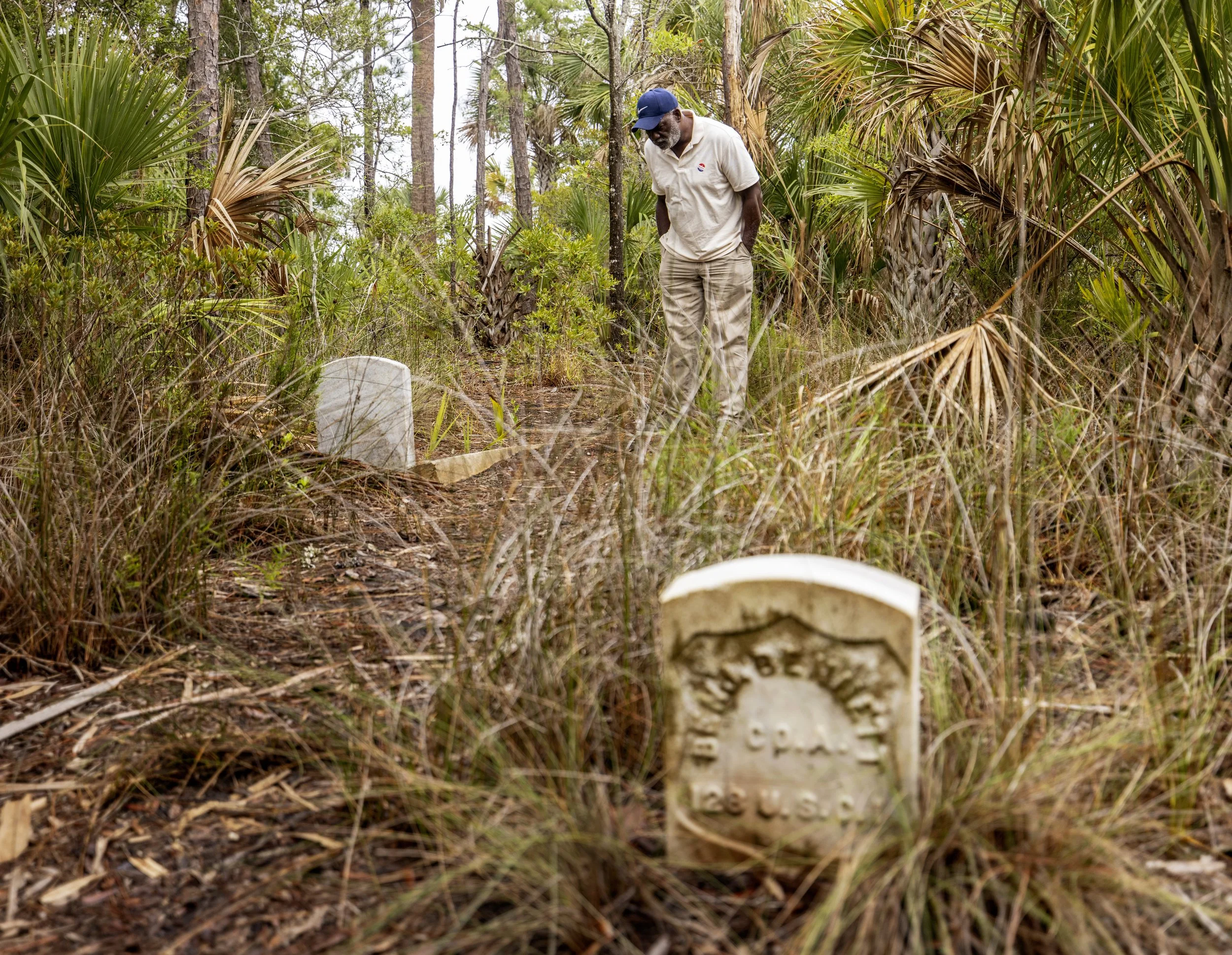
Richard Habersham looks at the gravestone of John Ernest Watson in a wooded area beside Parkers Island Cemetery Park in the RiverTowne neighborhood.
Habersham leads me to a few tombstones of Phillips’ founders lying just beyond the border fence. We find Benjamin Bennett of the 128th Regiment, United States Colored Infantry. Habersham tells me that Samuel Scott, another veteran of the USCI, is buried in the cemetery, but we can’t find the marker.
Habersham has not only his own genealogy and land history memorized, but also the history of many neighbors going back generations. He’s excited about the prospect of historical tourism, both to keep these stories alive and to create jobs within Phillips.
Habersham points to the leaning tombstone for Daniel Jermin, one of the Rev. Smalls’great-grandfathers.
In memory of Daniel Jerman
Born Nov. 24, 1832
Died Jan 8, 1901
He lived and died a true Christian and now is at rest.

Richard Habersham spreads a palmetto tree leaf to reveal the materials needed to make sweetgrass baskets.
As a child, Habersham would gather palm leaves, pine needles, and sweetgrass for basket making — another African artform that continues in Phillips and other Gullah-Geechee communities along the South Carolina and Georgia coasts. His sister and niece, as well as several neighbors, still sew baskets using techniques passed down through generations. The destruction of wild spaces makes it increasingly difficult to find materials, and many artists have to buy what their ancestors could easily gather. He reaches for a thick cluster of palm leaves at the base of a plant and fans them out between his fingers, “This is what they use to make the baskets.”
When we near a branch of Horlbeck Creek, he points to some bulrushes. The dampness in the air reminds you that this land where we stand is mostly water. “Have you ever heard the story of why cemeteries were close to the ocean or the creeks?” Habersham asks. “They was always facing toward Africa. They say that, since they were stolen, they buried them by the creeks so their spirits could go back home.”
We return to his car and drive through the subdivision. “See that stuff there?” He points to the landscaping — clusters of grasses growing along a wall.
“That’s a variation of sweetgrass right there, but that stuff ain’t no good for no baskets ’cause it’s so brittle. Once it dries, it crumbles out. Everybody thinks it’s sweetgrass but it's not, it’s just a variation. The sweetgrass grows all in the cemetery, around there,” he says, pointing back.
In the tangled web of history, water, and land, the people of Phillips, like those in all settlement communities along the coast, are working hard to stay on the map, to be communities that hold together and don’t crumble.
The Army Corps of Engineers will review the revised plan for a three-lane highway in fall 2022; an open comment period will follow.
Josina Guess is a senior writer for The Bitter Southerner, a student in the Narrative Nonfiction MFA program at the University of Georgia Grady College of Journalism and Mass Communication (Class of 2023), and a contributor to Bigger Than Bravery: Black Resilience and Reclamation in a Time of Pandemic, edited by Valerie Boyd (Lookout Books Fall 2022). Read more at Josinaguess.com.
Gavin McIntyre is a photographer in Charleston, South Carolina, who documents the everyday life of people in his community. You can find more of his work at gavinmcintyre.squarespace.com.